Key Points
- Distance & Difficulty: 8.5 miles (13.7km) with moderate elevation changes; difficulty rating 6/10
- Elevation Profile: Undulating terrain with the ascent to Walltown Crags being the most challenging section, gaining approximately 150 metres
- Well-Waymarked Route: Clear National Trail markers throughout, with excellent signage at key junctions
- Good Facilities: Multiple options for water, toilets, lunch stops and emergency exits via public transport
- Spectacular Roman Sites: Features Vindolanda, Housesteads Roman Fort, and stunning stretches of original Wall
- Suitable for Self-Guided Walkers: Well-maintained paths with plenty of access points make this ideal for walking holidays with baggage transfer
Overview of the Route
This section of the Hadrian’s Wall Path represents one of the most rewarding yet manageable stretches along the entire 84-mile National Trail. The landscape between these two villages showcases the dramatic undulations of the Whin Sill escarpment, where some of the finest surviving sections of Hadrian’s Wall march across windswept crags.
The route can be walked comfortably in either direction. Those travelling west from Once Brewed to Gilsland face a challenging early climb to Walltown Crags before gentler terrain towards the finish. Walkers heading east from Gilsland enjoy a more gradual warm-up before tackling the crags in the latter half. Both directions offer distinct advantages depending on fitness levels and weather conditions.
Starting Points and Transport Links
Once Brewed (Also Known as Twice Brewed)
Once Brewed sits on the B6318 Military Road and offers good facilities for walkers embarking on this section. The village name allegedly derives from a traveller’s complaint about weak beer, though locals enjoy debating the true origin.
Key facilities:
- The Twice Brewed Inn (accommodation, meals, packed lunches)
- Sill National Landscape Discovery Centre (café, toilets, visitor information)
- Youth Hostel with walker facilities
- Bus services: AD122 Hadrian’s Wall Country Bus (seasonal, late May to September)
Gilsland
This attractive village straddles the Cumbria-Northumberland border and provides a welcoming endpoint or starting point.
Key facilities:
- Gilsland Spa Hotel (accommodation and meals)
- Village shop
- Bus services: AD122 connects to Carlisle and Hexham during summer months
For walkers undertaking self-guided walking holidays, both villages offer convenient baggage transfer collection and drop-off points. Year-round access is available via taxi services from Hexham, Haltwhistle or Carlisle, essential for those walking outside the summer bus season.
Detailed Route Description
The Western Section (Gilsland Direction)
Departing from the area around Once Brewed, the path follows the B6318 briefly before turning north towards Vindolanda, one of Britain’s most significant Roman archaeological sites. Though the fort lies slightly off the main path (approximately 1km detour), many walkers incorporate this visit, particularly if staying overnight in the area.
The Trail itself continues westward, climbing steadily through farmland before meeting the Wall itself at Cawfields. Here, walkers encounter their first dramatic views across Northumberland National Park, with the Wall snaking across the landscape ahead.
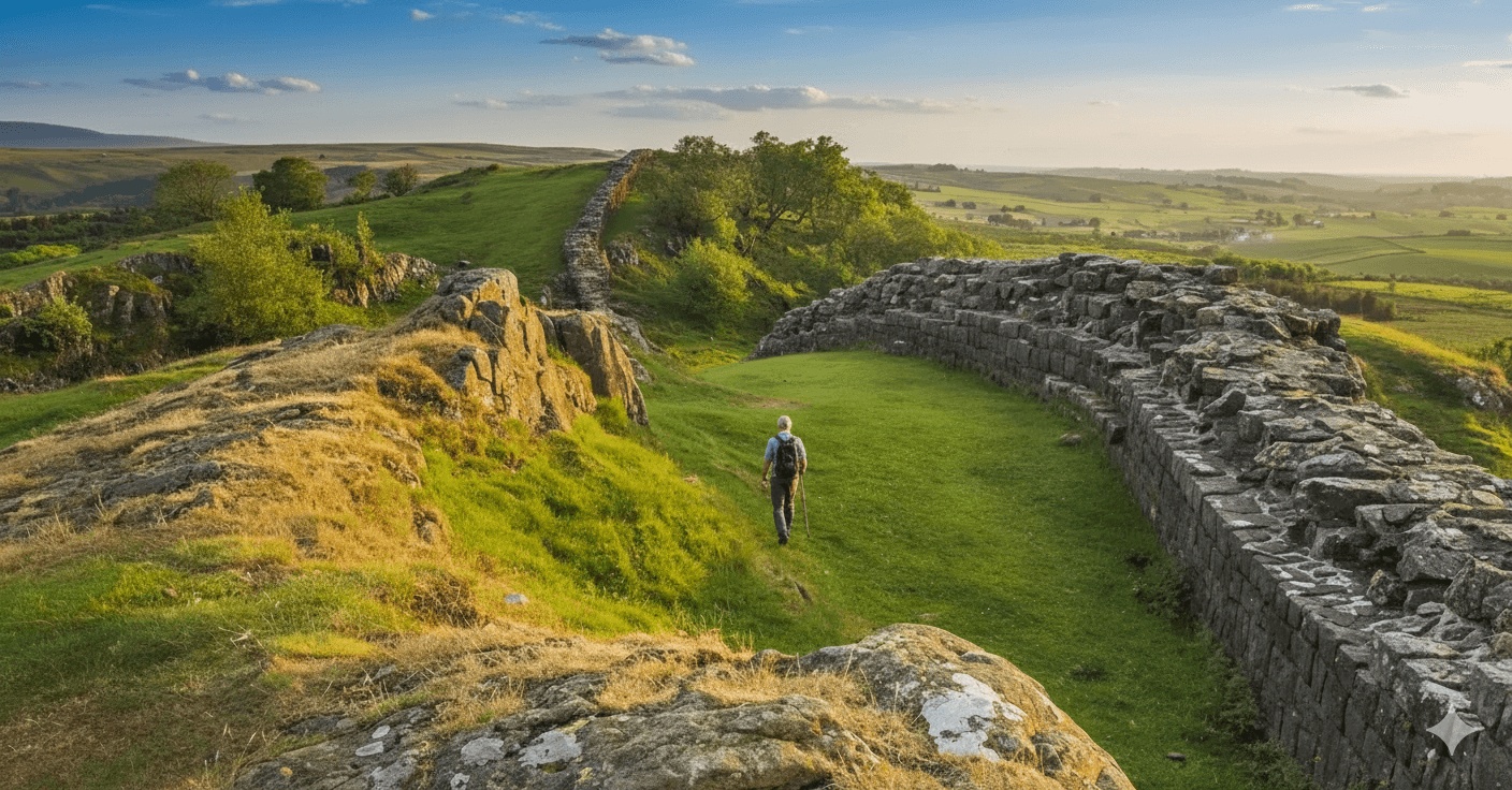
Central Section: The Crags
This segment contains the day’s most challenging terrain but rewards with outstanding scenery. The path follows the Wall along:
- Walltown Crags: A steep ascent and descent requiring careful footing, especially in wet conditions
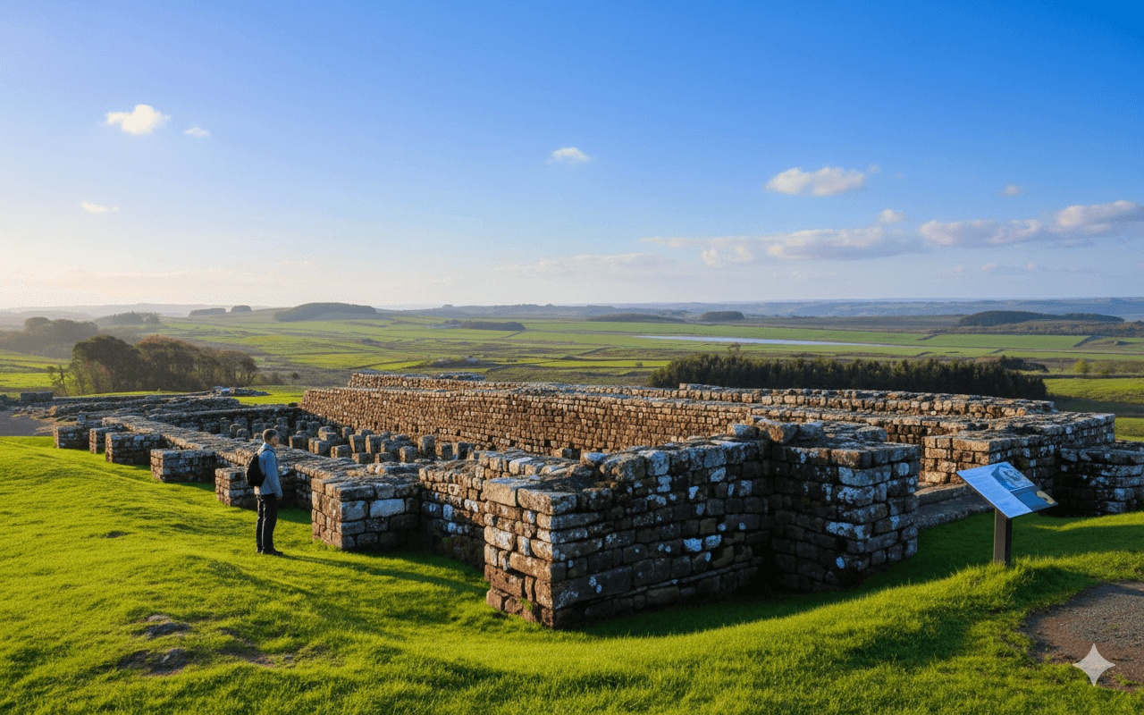
- Great Chesters Roman Fort (Aesica): Visible remains just off the path
- Cawfields Quarry: Now a peaceful lake, once a working quarry that unfortunately destroyed sections of the Wall
The elevation gains along this section total approximately 150 metres, with multiple short, sharp climbs rather than one continuous ascent. The narrow path along the crag tops requires concentration, and walkers should take particular care in high winds or icy conditions.
Eastern Section (Once Brewed Direction)
Approaching from Gilsland, walkers begin with gentler farmland walking before the terrain becomes progressively more dramatic. The village itself sits in a peaceful vale, and the initial miles provide an excellent warm-up.
The path crosses several stiles and field boundaries, all clearly waymarked with the National Trail’s distinctive acorn symbol. Approximately 4 miles from Gilsland, the landscape begins to rise as Walltown Crags come into view.
Elevation Profile and Terrain
Difficulty Rating: 6/10
This rating reflects several factors:
- Cumulative elevation: Approximately 400 metres of ascent regardless of direction
- Path surfaces: Mix of grass, gravel, boardwalks and occasional rocky sections
- Technical difficulty: Some steep, uneven sections requiring good balance
- Distance: Achievable for moderately fit walkers but long enough to be tiring
- Exposure: Exposed ridge sections can be challenging in adverse weather
The route suits walkers comfortable with uneven ground and moderate hills. Those with knee problems may find the descents from the crags challenging, particularly when walking westbound from Once Brewed, as the steepest descent comes early in the day.
The Hadrian’s Wall Path between these two points enjoys excellent waymarking. The National Trail markers appear regularly, supplemented by Hadrian’s Wall Path-specific signage at major junctions.
Key navigational notes:
- The route follows the actual Wall for significant stretches, providing a natural guide
- Several points where the path temporarily leaves the Wall line are clearly signed
- Ordnance Survey Explorer Map OL43 (Hadrian’s Wall) recommended, though not essential for this section
- Mobile phone signal is generally available but can be patchy in valleys
- All gates and stiles clearly marked with waymarkers
Most walkers find the route intuitive to follow. The main potential confusion occurs near Cawfields, where paths lead to and from the quarry car park. However, clear signage guides walkers through this area.
Water Sources and Toilet Facilities
Reliable Facilities
Once Brewed/Twice Brewed area:
- The Sill (café and toilets, open daily March–October, weekends November–February)
- Twice Brewed Inn (open to non-residents)
- Youth Hostel (for residents)
En route:
- Cawfields Quarry car park: Seasonal toilets (generally Easter–October)
- No other guaranteed facilities between Once Brewed and Gilsland
Gilsland:
- Public toilets near village centre
- Gilsland Spa Hotel (open to walkers)
Water Carrying
Walkers should carry at least 1.5 litres of water, particularly on warm days. The exposed sections offer no natural water sources, and the only reliable mid-route refill point is the seasonal facilities at Cawfields. Self-guided walkers cannot rely on finding water sources along this section, so adequate supplies from the start are essential.
Lunch Options and Pub Stops
This section presents limited mid-route refreshment options, making packed lunches advisable for most walkers.
Packed Lunch Recommendations
Many accommodations along the Hadrian’s Wall Path, including those in Once Brewed and Gilsland, offer packed lunch services for guests. Ordering the evening before ensures collection at breakfast time. Typical costs range from £7–12 for a substantial lunch including sandwiches, snacks, fruit and drink.
Cawfields Quarry
The car park area offers:
- Ice cream van (seasonal, typically Easter–October weekends and summer daily)
- Picnic tables with spectacular views
- Sheltered spots for lunch breaks
This location sits approximately midway through the walk and provides an ideal lunch stop with facilities and seating.
Off-Route Options
Those walking from Once Brewed could detour to Vindolanda’s café (approximately 1km off-path). However, this adds 30–45 minutes to the day’s walking and may not suit those with tight schedules or pre-arranged accommodation check-in times.
Emergency Exits and Public Transport
Mid-Route Exit Points
Several locations offer escape routes if walkers need to abandon the day’s walk due to weather, injury or tiredness:
Cawfields Quarry:
- Car park with roadside access to B6318
- Taxi collection point
- AD122 bus stop (seasonal service)
- Approximately 4 miles from Once Brewed, 4.5 miles from Gilsland
Shield-on-the-Wall:
- Small parking area
- Taxi pickup available
- Access to B6318
- Approximately 2 miles from Gilsland
Public Transport Connections
The AD122 Hadrian’s Wall Country Bus operates late May through September, typically daily between 9:30am and 5:30pm. This service connects all major points along the Wall, making it invaluable for:
- Returning to accommodation if walking point-to-point
- Emergency exits
- Accessing attractions slightly off the path
Self-guided walking holiday companies typically provide comprehensive transport information and emergency contact numbers as part of their service.
Weather Considerations and Best Times
The exposed nature of the Wall crags makes weather a significant consideration. The ridge sections offer little shelter from wind or rain, and conditions can deteriorate rapidly.
Seasonal Considerations
April–June: Often the driest months with longer daylight hours. Wild flowers enhance the landscape, and lambing season brings life to the fields.
July–August: Peak season with warmest temperatures but also busiest paths and occasional summer storms. Book accommodation well in advance.
September–October: Excellent walking with autumn colours, fewer crowds, and generally stable weather. However, daylight hours shorten significantly by late October.
Weather Preparation
- Check forecasts for the specific area, not just regional predictions
- Exposed sections can be 5–7°C cooler than sheltered valleys
- Wind speeds often double on the crags compared to lower ground
- Waterproof layers essential year-round
- Sun protection required even on overcast days due to exposure
Historical Significance
Walking between these two points takes walkers through almost 2,000 years of history. The Wall itself dates to AD 122, when Emperor Hadrian ordered its construction as the northern frontier of the Roman Empire.
Key Historical Sites
Great Chesters Roman Fort (Aesica): Housed approximately 500 auxiliary soldiers. The visible remains include fort walls and gate positions. The fort’s remote location meant it relied heavily on supply routes along the Wall.
Walltown Crags: Some of the best-preserved sections of the Wall demonstrate Roman engineering prowess. The foundations carved directly into the rock remain visible in many places.
The Vallum: This earthwork running parallel to the Wall is clearly visible in several sections, particularly approaching Gilsland. Its purpose remains debated, though most archaeologists believe it marked the military zone’s southern boundary.
Practical Walking Tips
Footwear and Equipment
- Waterproof walking boots essential; the terrain includes muddy sections even in summer
- Walking poles helpful for the steep crag descents
- Layered clothing to adapt to changing conditions
- Rucksack comfortable for 5–6 hours of walking
Timing Your Walk
Most walkers complete this section in 4.5–6 hours, depending on:
- Fitness levels
- Frequency of photo stops (the scenery demands photography)
- Lunch break duration
- Terrain conditions
Starting by 9:00am ensures arrival at the destination by mid-afternoon, allowing time for accommodation check-in and exploration of the arrival village. Self-guided walkers appreciate the flexibility to set their own pace without pressure from group schedules.
Photography Opportunities
The dramatic landscape provides outstanding photography throughout. Particular highlights include:
- Walltown Crags looking east and west along the Wall
- Cawfields Quarry lake with Wall reflections
- Sunset from the crags (for those staying locally)
- Early morning mist in the valleys
Wildlife and Nature
Northumberland National Park supports diverse wildlife. Patient observers may spot:
- Curlews and lapwings (ground-nesting birds, especially vocal in spring)
- Skylarks singing above the grasslands
- Red squirrels in woodland sections
- Roe deer in early morning or evening
- Numerous butterfly species on sunny days
The area forms part of the Hadrian’s Wall Heritage Site and National Park, with conservation efforts maintaining the landscape’s character whilst accommodating walkers.
Accommodation and Baggage Transfer
Both Once Brewed and Gilsland offer accommodation ranging from camping to hotels. Self-guided walking holidays typically include:
- Pre-booked accommodation with confirmed reservations
- Daily baggage transfer between overnight stops
- Detailed route notes and maps
- Emergency contact numbers
- Flexibility to add rest days or extra nights
Baggage transfer services collect luggage from accommodation reception areas between approximately 9:00am–10:00am, delivering to the next night’s accommodation by mid-afternoon. This service transforms the walking experience, allowing walkers to carry only a small daypack with essentials.
Accessibility Considerations
This section presents significant challenges for those with limited mobility:
- Multiple steep climbs and descents
- Narrow paths unsuitable for wheelchairs or mobility scooters
- Stiles and gates throughout (though many have been replaced with kissing gates)
- Uneven, rocky terrain in places
The Hadrian’s Wall Path National Trail includes more accessible sections, but this particular stretch suits confident, reasonably fit walkers only.
FAQs
How difficult is the walk from Once Brewed to Gilsland?
The route receives a difficulty rating of 6/10, making it moderately challenging rather than strenuous. The main difficulties come from the steep sections along Walltown Crags and the undulating terrain throughout. Walkers with reasonable fitness who are comfortable with 8–9 miles of mixed terrain should manage this section successfully. The cumulative elevation gain of approximately 400 metres is spread across the distance rather than concentrated in one climb.
Can I walk this section in winter?
Winter walking is possible but requires additional preparation and experience. The days are short (daylight from around 8:30am to 4:00pm in December), facilities are limited or closed, and the AD122 bus doesn’t operate. Weather conditions can be harsh on the exposed sections, with strong winds and occasional snow or ice making the crag sections potentially dangerous. Winter walkers should have proper equipment, navigation skills, and inform someone of their plans.
Where can I refill water bottles along this route?
Water refill opportunities are limited between Once Brewed and Gilsland. The Sill at Once Brewed and facilities in Gilsland provide reliable water sources at either end. The seasonal facilities at Cawfields Quarry (typically Easter–October) offer the only mid-route option, but walkers cannot rely on this being open. Carrying sufficient water from the start is essential—at least 1.5 litres per person, more in warm weather.
Is the route clearly signposted?
The Hadrian’s Wall Path enjoys excellent waymarking throughout this section. National Trail acorn markers appear regularly on posts, gates and stiles, supplemented by Hadrian’s Wall Path-specific signage at major junctions. The Wall itself provides a natural navigational guide for much of the route. While carrying a map (OS Explorer OL43) is recommended as good practice, most walkers find the signage sufficient to navigate confidently without constant map reference.
How long does it take to walk from Once Brewed to Gilsland?
Most walkers complete the 8.5-mile route in 4.5–6 hours of walking time. This includes brief rest stops but not an extended lunch break. The terrain’s undulating nature and several steep sections mean this isn’t a fast walk despite the relatively modest distance. Factors affecting timing include fitness levels, weather conditions, photography stops, and whether walkers detour to visit forts or facilities. Planning for 6–7 hours total (including a 30-minute lunch stop) ensures a comfortable pace without rushing.
Are there pubs or cafés en route for lunch?
Unlike some Hadrian’s Wall Path sections, this stretch has no pubs or cafés directly on the route between Once Brewed and Gilsland. Cawfields Quarry sometimes has a seasonal ice cream van and provides picnic tables, but walkers should not rely on finding food to purchase. Most self-guided walkers carry packed lunches, which accommodations can usually provide if ordered the evening before. The lack of facilities makes this section feel more remote and wild, part of its appeal for many walkers.