Key Points / Quick Summary
- Distance & Difficulty: 14.5 miles (23.3 km) of mostly gentle terrain with one moderate ascent — difficulty rating 5/10
- Roman Heritage: Pass Planetrees Roman Wall remains and approach the significant Roman fort at Chesters
- Facilities: Limited water points en route; plan accordingly and carry sufficient supplies for this rural stretch
- Transport Links: Regular bus services at both ends plus mid-route options at Chollerford for flexible itinerary planning
- Terrain: Predominantly agricultural land with clear waymarking through fields, minor roads, and established footpaths
- Refreshments: Pub options at the Chollerford end; limited facilities mid-route so pack provisions
Overview of This Hadrian’s Wall Path Section
This section of the Hadrian’s Wall Path takes walkers through quintessentially Northumberland countryside, transitioning from the suburban edges of Newcastle’s western reaches into increasingly rural farmland. The route offers a gentler walking day compared to the challenging sections further west, making it an accessible choice for those building stamina or seeking a less strenuous stage on their self-guided walking holiday.
The landscape here reveals why the Romans chose this corridor for their frontier — the elevated ground provides natural defensive advantages whilst remaining navigable for a major fortification. Walkers experience a satisfying blend of open countryside, riverside walking, and tangible Roman archaeology, with the Wall’s remains becoming more prominent as the route progresses.
Distance and Elevation Profile
The Numbers
The walking distance covers approximately 14.5 miles (23.3 km) between these two points. This represents a full day’s walking for most people, typically requiring 5.5 to 7 hours depending on pace and stops.
Elevation Changes
The elevation profile for this section remains relatively forgiving. Starting from Heddon-on-the-Wall at roughly 100 metres elevation, the route gradually climbs through the opening miles before descending towards the North Tyne valley. The most notable ascent occurs in the middle section between Harlow Hill and Whittle Dene, where walkers gain approximately 60 metres over a steady climb.
The overall elevation gain sits around 200 metres across the entire distance, with corresponding descent. This makes it considerably less demanding than the famous crags section further west. Those walking from Chollerford towards Heddon-on-the-Wall will experience a slightly different profile, with the gradual descent coming earlier and the modest climb arriving in the latter half.
Difficulty Rating: 5/10 — This rating reflects the distance rather than technical difficulty. The terrain poses few challenges, but the length requires reasonable fitness. The gentle gradients suit walkers preferring less strenuous days whilst still covering meaningful distance on the Hadrian’s Wall Path.
Wayfinding and Navigation
Signposting Quality
The Hadrian’s Wall Path benefits from consistent National Trail waymarking throughout this section. The distinctive acorn symbol appears regularly on wooden posts and gates, supplemented by periodic stone markers bearing the National Trail logo. Directional signage at key junctions prevents wrong turns.
Route Characteristics
Navigation remains straightforward for most of this stretch. The path follows:
- Established field boundaries with stiles and gates
- Quiet minor roads through hamlets
- Farm tracks with clear right-of-way
- Riverside sections with obvious paths
- Archaeological features that serve as landmarks
The route through agricultural land means walking across working farms. Gates must be closed behind walkers, and livestock may be present. Some fields can become muddy in wet conditions, particularly in the sections approaching Chollerford where the path runs closer to the North Tyne.
Potential Navigation Points
Between Heddon-on-the-Wall and Harlow Hill, the route crosses several minor roads and passes through residential areas where attention to waymarkers prevents straying onto incorrect paths. At Whittle Dene Reservoirs, clear signage directs walkers around the water features.
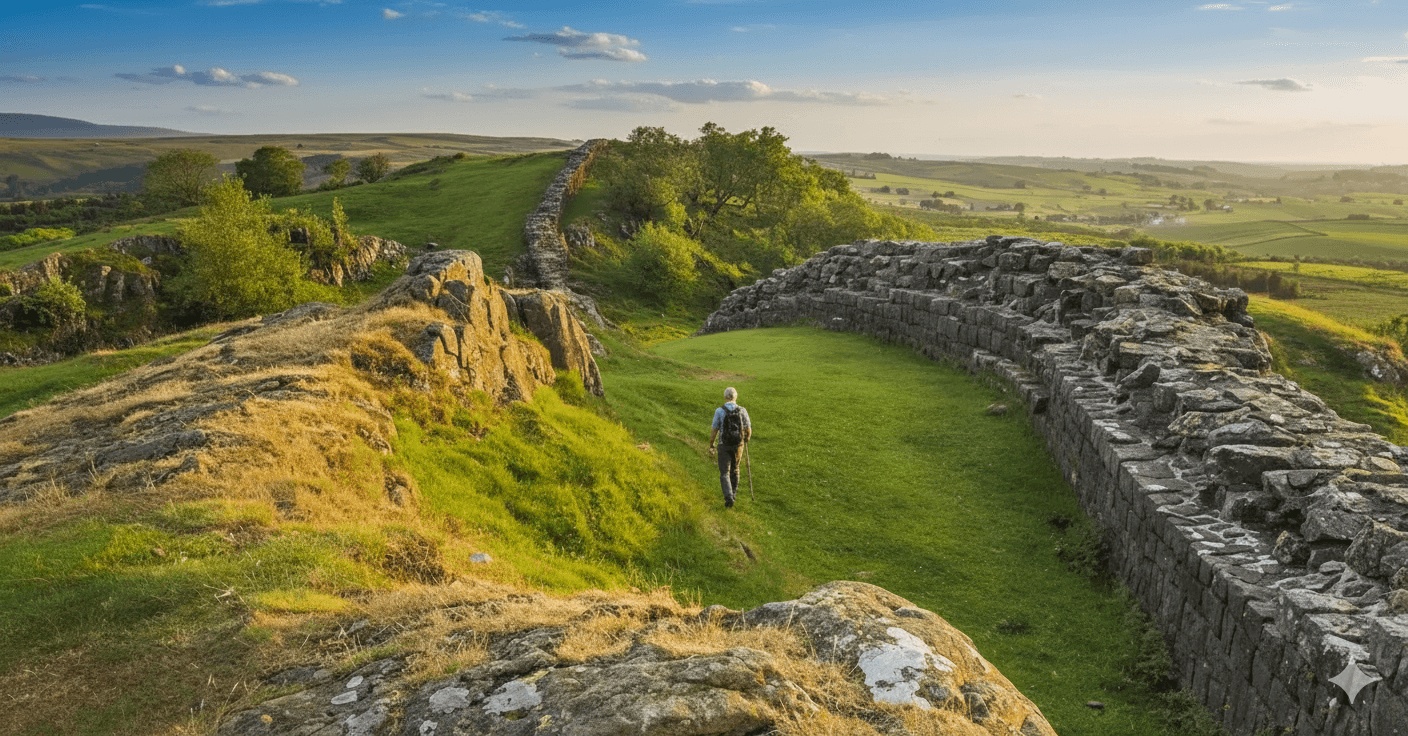
The section approaching Planetrees requires care — this is where substantial Roman Wall remains first appear, and the temptation to explore can divert attention from the marked path. Stay alert for waymarkers through this historically significant area.
Most smartphones maintain signal throughout this section, allowing GPS backup if needed. However, downloading offline maps before departure remains sensible practice for any self-guided walk.
Water Points and Toilet Facilities
Water Availability
This section presents challenges for water refills. Unlike more frequented stages of the Hadrian’s Wall Path, public water points are scarce. Walkers should carry sufficient water for the entire distance — a minimum of 1.5 litres per person, more in warm weather.
The village of Heddon-on-the-Wall has a community shop where bottles can be purchased before setting off. At the Chollerford end, The George Hotel provides facilities for customers. Between these points, no reliable public water sources exist.
Public Conveniences
Public toilet facilities are similarly limited. Heddon-on-the-Wall does not have dedicated public toilets, though the village pub may accommodate customers. Chollerford has facilities at The George Hotel and nearby Chesters Roman Fort visitor centre (when open).
This lack of facilities underscores the rural nature of this section. Walkers on a self-guided walking holiday should plan accordingly, using facilities before departure and knowing that the next convenient stop comes at the day’s end.
Refreshment Stops and Lunch Options
Food and Drink En Route
This remains one of the more challenging sections of the Hadrian’s Wall Path for refreshment stops. The route passes through agricultural countryside with limited commercial establishments.
At the Heddon-on-the-Wall End:
- The Swan Inn offers traditional pub food and welcomes walkers
- Small village shop for supplies and packed lunch items
Mid-Route: Minimal options exist between the two endpoints. Pack a substantial packed lunch and snacks. Several spots offer pleasant picnic opportunities, particularly near Planetrees where Roman Wall remains provide atmospheric seating options, or alongside the wooded sections approaching Chollerford.
At the Chollerford End:
- The George Hotel at Chollerford provides restaurant and bar meals in a historic coaching inn setting
- Walby Farm Shop (slight detour) offers café facilities and local produce
- Options expand at nearby Hexham (short bus journey) with wider café and restaurant choices
Planning Your Lunch Stop
Most walkers stop for lunch around the halfway mark, roughly 7 miles into the walk. The area near Planetrees Roman Wall offers sheltered spots amongst the archaeological remains. In inclement weather, the wooded sections near Whittle Dene Reservoirs provide some protection from wind.
Those walking as part of a self-guided Hadrian’s Wall package should confirm whether packed lunches can be arranged through their accommodation provider, particularly useful on sections with limited facilities like this one.
Transport Connections and Alternative Exit Points
Access at Both Ends
Heddon-on-the-Wall: Regular bus services connect to Newcastle upon Tyne, with the X85 and 684 routes running throughout the day. The bus stop sits on the main road through the village. Service frequency makes this a practical starting or finishing point, with connections to Newcastle’s central station for those arriving by rail.
Chollerford: The AD122 Hadrian’s Wall Country Bus operates seasonally (typically Easter to September) and stops at Chollerford, connecting to Hexham, Once Brewed, and other key points along the Wall. Year-round, the 880 bus service runs between Hexham and Bellingham, stopping at Chollerford. Hexham railway station, approximately 3.5 miles from Chollerford, provides mainline connections.
Mid-Route Exit Options
The rural nature of this section means mid-route exits require more planning:
Harlow Hill (approximately 3.5 miles from Heddon-on-the-Wall): Minor road access allows taxi pickup. No regular bus services at this specific point.
Wall Village (approximately 10 miles from Heddon-on-the-Wall): The 880 bus service stops here, providing an option to curtail the walk if needed. This village sits close to the Roman fort of Corstopitum (Corbridge) for those interested in extending their Roman archaeology experience.
Taxi Services
Local taxi firms serve this area, though pre-booking is essential as hailing taxis roadside is impossible in rural Northumberland. Hexham-based taxi companies cover this section, with typical journey times of 15-20 minutes to reach the market town.
Having taxi contact numbers saved before departure provides peace of mind. Accommodation providers offering self-guided walking packages typically maintain relationships with reliable local taxi services and can arrange pickups if walkers need to adjust their itinerary.
Terrain and Path Conditions
What to Expect Underfoot
The path surface varies throughout this section:
- Improved paths: Sections near settlements feature hardstanding or well-maintained footpaths
- Grass paths: Field boundaries and agricultural land mean walking on grass for extended periods; these can become slippery when wet
- Farm tracks: Occasional stony tracks provide firmer footing
- Minor roads: Short sections of quiet country lanes with minimal traffic
- Riverside paths: Approaching Chollerford, the path runs closer to the North Tyne with potentially softer, damper ground
Seasonal Considerations
Spring and autumn can leave paths muddy, particularly through fields and gates where livestock congregate. Waterproof walking boots with good ankle support remain essential. Summer offers the driest conditions, though crops in fields may grow high, narrowing paths in places.
Winter walking on this section is feasible — the terrain lacks the exposure of higher sections further west — but shorter days limit the walking window. Ice can make stiles and steep stiles hazardous in freezing conditions.
Points of Interest Along the Route
Roman Heritage
This section transitions into increasingly visible Roman archaeology:
Planetrees Roman Wall: One of the first substantial sections of visible Wall encountered when walking west from Newcastle. The remains here show both facing stones and core material, offering insight into Roman construction techniques. Information boards provide context.
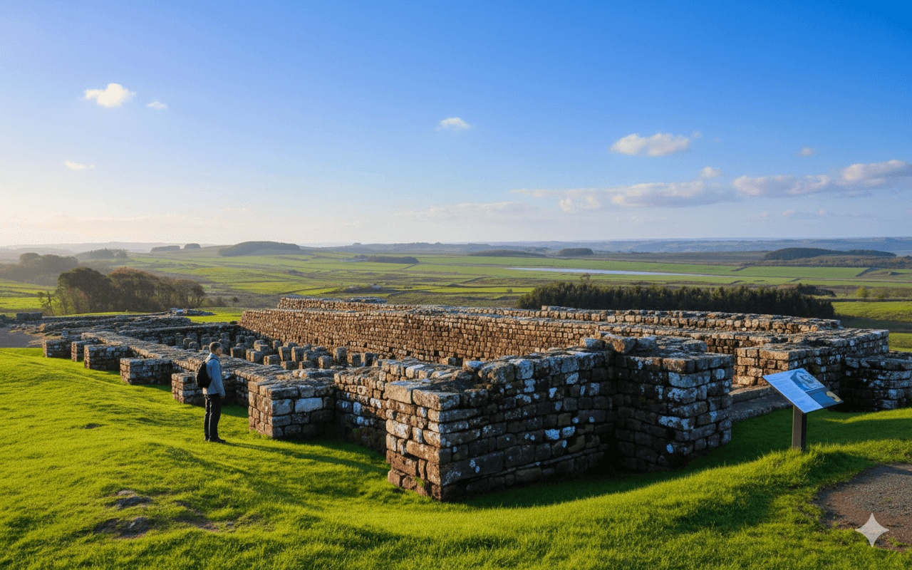
Approaching Chesters: As the route nears Chollerford, anticipation builds for Chesters Roman Fort, one of the best-preserved cavalry forts on the entire Wall. Whilst the fort itself sits just beyond Chollerford, its commanding position becomes apparent as walkers approach.
Natural Environment
The route passes Whittle Dene Reservoirs, created in the Victorian era to supply Newcastle with water. The wooded surrounds provide habitat for varied birdlife. In spring, the hedgerows throughout this section burst with hawthorn and blackthorn blossom, whilst autumn brings spectacular colour to the mixed deciduous woodland.
The North Tyne valley, visible as walkers approach Chollerford, demonstrates the strategic thinking behind the Wall’s placement — the river provided a natural defensive feature supplementing the Roman fortification.
Preparing for This Section
What to Pack
For this particular stretch, walkers should ensure they carry:
- Sufficient water (1.5-2 litres per person minimum)
- Full packed lunch plus snacks
- Weather-appropriate clothing layers
- Waterproof jacket and trousers
- Walking boots with good tread
- Blister kit and basic first aid
- Charged mobile phone
- Printed or downloaded maps as backup
- Small amount of cash (card payments not guaranteed in remote areas)
Fitness Requirements
The 5/10 difficulty rating assumes reasonable fitness. Walkers comfortable with 14-15 mile days on varied terrain should find this section achievable. The gentle gradients reduce cardiovascular demand compared to hillier sections, but the distance still requires stamina.
Those new to long-distance walking might consider this section as part of building towards the more challenging central sections of Hadrian’s Wall Path. The straightforward navigation and escape routes via roads make it suitable for gaining confidence before tackling exposed high sections.
Accommodation Considerations
Both Heddon-on-the-Wall and Chollerford offer accommodation options, though Chollerford has fewer bed spaces. Many walkers on self-guided Hadrian’s Wall holidays stay in nearby Hexham (3.5 miles from Chollerford) where accommodation variety increases significantly.
When booking a self-guided walking package, baggage transfer services prove invaluable on this section. Carrying full packs for 14.5 miles increases fatigue considerably. Reputable operators collect luggage from morning accommodation and deliver it to the next night’s lodging, allowing walkers to carry only day essentials.
The flexibility to walk this section in either direction means itinerary planning can accommodate personal preferences and accommodation availability. Some walkers prefer reaching Chollerford to access Hexham’s amenities, whilst others enjoy finishing at Heddon-on-the-Wall with easy transport back to Newcastle.
Weather Patterns in This Part of Northumberland
This inland section experiences typical North Pennine weather patterns — changeable and potentially wet regardless of season. The lack of high ground means exposure to severe wind is less than on the crags section, but rain remains frequent.
Northumberland receives lower rainfall than the western Lake District, yet walkers should always prepare for wet conditions. The prevailing south-westerly winds mean rain often arrives from behind when walking west towards Chollerford, and faces walkers heading the opposite direction.
Summer temperatures typically reach 18-22°C, comfortable for walking with appropriate layering. Winter temperatures hover around 3-7°C, with occasional drops below freezing overnight. Mist can reduce visibility in the North Tyne valley, though this rarely causes significant navigation problems on well-marked paths.
Connecting to Your Wider Hadrian’s Wall Journey
This section forms part of the western approaches to Newcastle when walking east, or represents one of the first rural sections when walking west from the city. Its positioning makes it significant as a transition stage — urban Tyneside gives way to the open Northumberland countryside that characterises the Wall’s central sections.
For those walking the complete Hadrian’s Wall Path, this stage typically falls on day 2 or day 6 of a 7-day itinerary, depending on direction. The relatively gentle terrain allows recovery from more demanding sections or builds strength for challenges ahead.
Self-guided walking packages often structure itineraries to balance easier and harder days. This section’s moderate difficulty rating makes it ideal for positioning before or after the demanding high crags between Chollerford and Carlisle.
Frequently Asked Questions
How long does it take to walk from Heddon-on-the-Wall to Chollerford?
Most walkers complete this 14.5-mile section in 5.5 to 7 hours of actual walking time. Adding breaks for lunch, photographs, and exploring Roman remains typically extends the day to 7-9 hours total. Faster walkers might complete it in 5 hours, whilst those preferring a leisurely pace with extended stops could take up to 8 hours. Personal fitness, weather conditions, and path conditions all influence timing.
Can I walk from Chollerford to Heddon-on-the-Wall instead?
Absolutely. The Hadrian’s Wall Path can be walked in either direction, and this section works equally well both ways. Walking from Chollerford towards Heddon-on-the-Wall means starting from a smaller settlement and finishing with easier access to Newcastle. The elevation profile reverses but remains gentle in both directions. Many self-guided walking packages offer flexibility in direction choice, allowing walkers to structure their itinerary based on accommodation availability and personal preferences.
Are there shops or cafés along this section of the walk?
Unfortunately, this remains one of the least serviced sections for refreshments. The route passes through predominantly agricultural land with no shops, cafés, or pubs between the endpoints. Walkers must carry all necessary food and water for the day. Both Heddon-on-the-Wall and Chollerford have facilities, but nothing exists mid-route. This makes proper planning essential — pack a substantial lunch and adequate water before setting off.
What’s the best time of year to walk this section?
Late spring through early autumn (May to September) offers the most reliable weather and longest daylight hours. The AD122 seasonal bus service also operates during these months, providing better transport flexibility at Chollerford. Summer brings drier paths and the highest temperatures, though this section rarely becomes uncomfortably hot. Autumn offers spectacular foliage colour along the wooded sections. Winter walking is possible but requires shorter day planning and preparation for potentially muddy conditions.
Is the path suitable for dogs?
Dogs are welcome on this section of the Hadrian’s Wall Path, though owners should be prepared for livestock in fields. Dogs must remain under close control, preferably on leads, when crossing farmland with sheep or cattle. Multiple stiles present challenges for larger dogs — some walkers use alternative harnesses or carry smaller dogs over obstacles. Sufficient water for dogs is essential as natural water sources are limited. Check that accommodation at both ends accepts dogs if planning a multi-day walking holiday.
Can I get mobile phone signal along this route?
Mobile phone signal remains generally good throughout this section, with most major networks providing coverage. The relatively low-lying terrain and proximity to major roads means signal drops are infrequent. Occasional weak spots occur in dips and valleys, particularly near Whittle Dene Reservoirs, but these are brief. Despite good coverage, downloading offline maps before departure remains sensible practice. Never rely solely on mobile connectivity for navigation on any rural walking route.