- The Hadrian’s Wall Path spans 84 miles from Wallsend to Bowness-on-Solway, typically walked west to east over 6–8 days
- Stage 3 (Chollerford to Steel Rigg) showcases the most dramatic scenery with Housesteads Roman Fort and the Whin Sill escarpment
- Each section averages 10–15 miles with varying terrain from urban paths to rugged moorland
- Strategic planning allows walkers to book accommodation and baggage transfer services between stages
- The trail passes eight Roman forts and numerous milecastles, offering unparalleled insight into frontier life
- Spring (April–May) and autumn (September–October) provide optimal walking conditions with fewer crowds
Planning Your Hadrian’s Wall Path Walk
Breaking down the Hadrian’s Wall Path into manageable daily stages transforms this historic long-distance route into an achievable walking holiday. Whether tackling the full 84 miles or selecting specific sections, understanding what each stage offers helps walkers prepare properly and ensures nothing significant gets missed along the way.
The National Trail officially runs coast to coast, but most walkers begin at Newcastle or Wallsend in the east and finish at Bowness-on-Solway in the west. Walking west means the sun stays behind walkers for most of the day, prevailing winds offer assistance rather than resistance, and the terrain gradually becomes easier as legs tire towards the end of the journey.
The Six-Stage Route Breakdown
Stage 1: Wallsend to Newcastle (4 miles) or Heddon-on-the-Wall (15 miles)
Many walkers choose to start at Wallsend’s Segedunum Roman Fort, the official eastern terminus. The reconstructed fort and museum provide excellent context before setting off. The initial miles through Newcastle follow the Tyne riverside, passing the iconic bridges and Baltic Centre for Contemporary Art. Urban walking dominates this section, but the city’s Roman heritage remains visible through museums and excavated sites.
For those wanting a proper first day’s walk, continuing to Heddon-on-the-Wall extends the stage to 15 miles. The landscape transitions from urban to rural beyond Newcastle, with the first visible sections of Hadrian’s Wall appearing near Denton. Accommodation options in Heddon-on-the-Wall include cosy pubs and B&Bs, making it a practical overnight stop.
Highlights:
- Segedunum Roman Fort, Baths and Museum
- Newcastle’s historic quayside
- First glimpses of the Wall near Denton
- Swan Inn at Heddon-on-the-Wall
Stage 2: Heddon-on-the-Wall to Chollerford (13 miles)
This transitional stage leaves suburbia behind completely. The path climbs steadily into Northumberland countryside, with expansive views developing across rolling farmland. The Wall itself remains largely buried through this section, but roadside information panels and the occasional exposed foundation keep Roman history present.
Chesters Roman Fort, situated just before Chollerford, ranks among the best-preserved cavalry forts on the entire Wall. The bathhouse beside the River North Tyne shows remarkable architectural detail, whilst the museum houses an exceptional collection of Roman sculpture and inscriptions. Allow 90 minutes minimum for exploration.
The stage ends at Chollerford, where the George Hotel has welcomed Wall walkers for generations. The village sits at a historic crossing point, and the medieval bridge foundations can still be seen.
Highlights:
- Rudchester Roman Fort (foundations)
- Planetrees Roman Wall section
- Chesters Roman Fort and Museum
- River North Tyne valley views
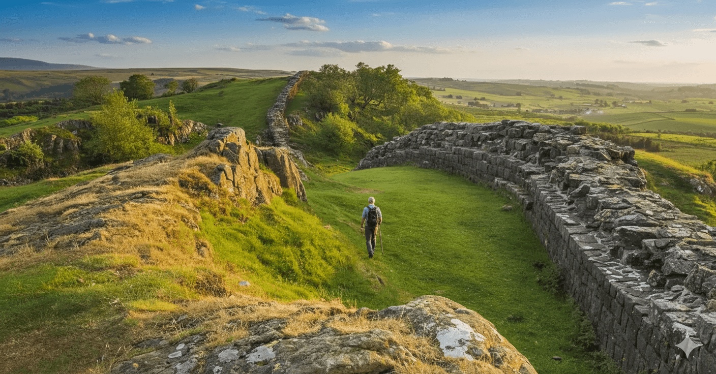
Stage 3: Chollerford to Steel Rigg via Once Brewed (13 miles)
Widely regarded as the finest section of the entire National Trail, Stage 3 delivers spectacular walking along the Whin Sill escarpment. The Wall clings dramatically to craggy ridges, with sheer drops to the north and sweeping views across the Northumberland National Park.
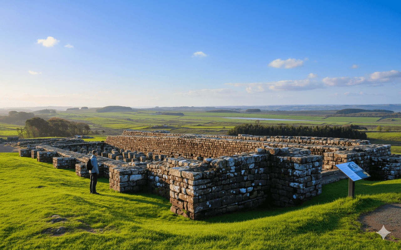
Housesteads Roman Fort dominates the central portion of this stage. Perched atop the escarpment, this infantry garrison once housed 800 soldiers. The site is remarkably complete, with barrack blocks, granaries, hospital and commanding officer’s house clearly visible. The communal latrines prove particularly memorable. Budget at least 90 minutes for Housesteads, ideally longer.
Beyond Housesteads, the path undulates dramatically along the crags. Sycamore Gap (tragically, the famous tree was felled in 2023, but the gap itself remains a stunning feature) precedes a challenging series of ascents and descents. This terrain requires good fitness and takes longer than the mileage suggests.
Once Brewed offers accommodation at the youth hostel and nearby inns, whilst Steel Rigg provides limited but excellent B&B options. Many walkers consider this the highlight stage and savour every mile.
Highlights:
- Brocolitia (Carrawburgh) Temple of Mithras
- Housesteads Roman Fort (UNESCO World Heritage Site)
- Sycamore Gap and the Whin Sill crags
- Vindolanda Fort (slight detour but absolutely worth it)
- The Roman Army Museum at Carvoran
- Sunset views from Winshields Crag (highest point on the Wall)
Stage 4: Steel Rigg to Walton (14 miles)
Following the previous day’s drama, Stage 4 offers gentler terrain but maintains historical interest. Birdoswald Roman Fort, approximately 8 miles from Steel Rigg, presents another well-preserved garrison. The east gate remains particularly impressive, and interactive displays bring frontier life vividly to reality. The fort’s tearoom provides welcome refreshment with commanding views.
The landscape softens beyond Birdoswald as the trail descends from the high country. The Wall becomes less prominent, though sections appear intermittently. The River Irthing marks a significant landscape transition, with the path entering gentler pastoral farmland.
Walton village offers limited but friendly accommodation. Alternatively, some walkers push on to Banks or break the stage at Gilsland (10 miles from Steel Rigg), where there are more accommodation choices.
Highlights:
- Cawfields Quarry and milecastle
- Great Chesters Roman Fort
- Birdoswald Roman Fort
- Medieval Lanercost Priory (short detour)
- River Irthing crossing
Stage 5: Walton to Carlisle (14 miles) or Burgh-by-Sands (18 miles)
The Wall’s western sections follow a different character entirely. Whilst the dramatic crags and well-preserved forts lie behind, this stage offers peaceful walking through the Eden Valley. The physical Wall largely disappears, though its line remains traceable through field boundaries and earthworks.
Carlisle, England’s most fought-over city, provides substantial historical interest beyond Roman occupation. The castle and cathedral deserve exploration, and the city offers excellent accommodation, restaurants and facilities. Walkers can rest here before the final push or continue to Burgh-by-Sands.
Those continuing find increasingly flat terrain as the trail approaches the Solway Firth. Burgh-by-Sands offers limited accommodation but sits close to the coast, making the final day shorter.
Highlights:
- Castlesteads Roman Fort (earthworks)
- Stanwix Roman Fort site (Carlisle’s northern suburb)
- Carlisle Castle and Tullie House Museum
- First views of the Solway Firth
- Burgh-by-Sands church (where Edward I died)
Stage 6: Carlisle (or Burgh-by-Sands) to Bowness-on-Solway (15 miles or 6 miles)
The final stage offers contemplative walking across marshland and beside the Solway Firth. This feels utterly different from the Wall’s central sections—flat, open and influenced by massive tidal ranges. Bird life thrives here, with the estuary supporting internationally important populations of waders and wildfowl.
The path skirts the salt marshes and follows sea defences, with views across to Scotland’s Dumfriesshire hills. On clear days, Criffel dominates the northern skyline. The walking proves easy underfoot after previous days’ exertions.
Bowness-on-Solway marks the western terminus. The village offers a banks pub/restaurant and limited B&B accommodation. The trail ends beside the Solway Firth, where a stone pavilion marks journey’s end. Walkers traditionally dip their boots in the water, mirroring the ceremonial start at Wallsend.
Highlights:
- Solway salt marshes and wetlands
- Drumburgh Castle (fortified tower)
- Port Carlisle’s abandoned canal basin
- Bowness-on-Solway church and village
- Trail’s end pavilion overlooking Scotland
Seven-Day and Eight-Day Options
Walkers seeking shorter daily distances can extend the journey to seven or eight days. This provides more time for fort exploration and reduces physical strain, particularly beneficial for those less accustomed to multi-day walks.
A typical seven-day itinerary might split Stage 3 (the toughest section) into two days, overnighting at Once Brewed. An eight-day route could add an extra night in Carlisle whilst exploring the city properly.
Practical Walking Considerations
Terrain and Difficulty
The Hadrian’s Wall Path varies considerably in character and challenge. Stages 1–2 offer relatively easy walking on good paths. Stage 3 presents the most demanding terrain with steep ascents and descents along the crags—proper walking boots prove essential here. Stages 4–6 gradually ease in difficulty, though accumulated fatigue affects many walkers.
Overall, the trail suits reasonably fit walkers comfortable covering 10–15 miles daily with a day pack. Those using baggage transfer services carry only essentials, significantly easing the physical burden.
Weather and Seasons
Northumberland’s weather changes rapidly, especially along the exposed central sections. Rain gear should always be carried, even during summer. The Wall’s higher sections can experience strong winds, and visibility sometimes drops dramatically in mist.
April through October provides the most reliable walking conditions. May and June offer long daylight hours and wildflowers, whilst September delivers autumn colours and fewer crowds. July and August see peak visitor numbers, particularly around major forts.
Winter walking remains possible but requires proper preparation. Daylight hours limit progress, some accommodation closes, and snow occasionally affects the higher sections. However, crisp winter days can be magical with fewer walkers and dramatic light.
Accommodation and Booking
Accommodation along the trail ranges from budget hostels to comfortable country hotels. The central sections (Stages 3–4) see highest demand, so booking well ahead proves essential during peak season. Villages like Once Brewed, Steel Rigg and Haltwhistle provide good options, though some involve short detours from the path.
Many walkers use baggage transfer services, allowing companies to move luggage between accommodations whilst carrying only a day pack. This transforms the experience, particularly over the challenging central sections.
Navigation and Waymarking
The Hadrian’s Wall Path follows National Trail status with excellent waymarking throughout. The distinctive acorn symbol appears regularly, and signage at junctions proves comprehensive. However, carrying a proper map (Ordnance Survey OL43 covers the central sections) and GPS device or smartphone app provides backup and helps identify features.
Several sections cross working farmland with multiple gates and stiles. Following waymarkers carefully prevents accidental trespassing or navigation errors.
Historical Context Along the Route
Understanding the Wall’s purpose enriches the walking experience immeasurably. Constructed from AD 122 onwards under Emperor Hadrian’s orders, the Wall marked Rome’s northwestern frontier for nearly 300 years. Rather than a simple defensive barrier, it controlled movement, enabled customs collection, and projected imperial power.
The Wall originally stood 15 feet high with a walkway on top. Milecastles every Roman mile housed small garrisons, whilst turrets between them provided observation points. Larger forts like Housesteads and Birdoswald housed cohorts who patrolled and controlled the frontier zone.
Vindolanda, just south of the Wall proper, yielded the famous writing tablets—thin wooden leaves bearing ink messages about daily life. These provide unparalleled insight into Roman military routine, from birthday party invitations to supply requisitions.
The Forts You’ll Encounter
Each major fort developed its own character and history:
Segedunum guarded the Wall’s eastern end where it met the Tyne. Its interactive museum excels at bringing Roman life to reality.
Chesters housed a cavalry unit and features Britain’s best-preserved Roman bathhouse. The riverside location provided essential water supplies.
Housesteads represents the classic infantry fort. Its remote hilltop position and completeness make it unmissable.
Vindolanda thrived for 80 years before Wall construction began. The ongoing excavations regularly yield spectacular finds.
Birdoswald sits above the dramatic River Irthing gorge. Its gateway and defences remain remarkably intact.
Beyond the Trail: What Makes This Walk Special
Hadrian’s Wall Path offers more than archaeological tourism or countryside walking—it provides immersion in Britain’s layered history. Medieval pele towers built from Roman stone, Victorian railways slicing through ancient earthworks, and modern farms following Roman field systems demonstrate continuity and change across two millennia.
The central sections’ dramatic scenery rivals any British National Trail. Walking the undulating crest with the Wall beside you, views stretching for miles, creates genuinely memorable experiences. Those spectacular crags weren’t chosen for defence—the Whin Sill’s geology simply provided the best foundation.
Wildlife thrives along the route. Red squirrels inhabit Northumberland’s woodlands, curlews call across the moorland, and the Solway’s wetlands teem with birds. Spring brings wildflowers to the grasslands, whilst autumn colours transform the deciduous woodlands.
Local communities have embraced the National Trail, developing infrastructure whilst maintaining authenticity. Village pubs welcome muddy walkers, B&B hosts share local knowledge, and small museums preserve remarkable collections. This infrastructure makes self-guided walking straightforward whilst retaining genuine character.
Frequently Asked Questions
How long does it take to walk Hadrian’s Wall Path?
Most walkers complete Hadrian’s Wall Path in 6–8 days, covering approximately 10–15 miles daily. Six-day itineraries suit fit walkers comfortable with longer distances, whilst seven or eight days allow more time for fort exploration and gentler daily mileage. Some walkers tackle the route over extended periods, completing individual sections during separate visits. The central stages between Chollerford and Walton require more time than distance alone suggests due to challenging terrain.
What is the hardest section of Hadrian’s Wall Path?
Stage 3, from Chollerford to Steel Rigg (or Once Brewed), presents the most challenging terrain. The route undulates dramatically along the Whin Sill escarpment with steep ascents and descents. Housesteads to Cawfields proves particularly demanding, though spectacularly rewarding. The rocky, uneven path requires concentration and proper footwear. However, this section also delivers the finest scenery and most impressive Wall remains, making the effort worthwhile. Breaking this stage into two days reduces difficulty significantly.
Can you walk Hadrian’s Wall without camping?
Absolutely—numerous B&Bs, guesthouses, hotels and hostels line the entire route, making camping unnecessary. The central sections offer the densest accommodation concentration, whilst the eastern and western portions require more planning. Booking ahead proves essential during peak season (May–September). Many walkers use baggage transfer services, allowing companies to move luggage between accommodations whilst carrying only day packs. This approach provides comfortable beds nightly without the burden of full camping equipment.
Which direction should you walk Hadrian’s Wall?
Most walkers travel west to east, starting at Wallsend or Newcastle and finishing at Bowness-on-Solway. This direction keeps the sun behind you, provides assistance from prevailing westerly winds, and gradually eases terrain difficulty as the journey progresses—the challenging central sections come mid-route when fitness peaks, whilst the gentler western stages suit tired legs. However, east-to-west remains perfectly viable and offers advantages like afternoon light on the Wall’s best-preserved sections.
Do you need to pay to enter the Roman forts?
Major excavated forts charge admission fees. Housesteads, Vindolanda, Birdoswald and Chesters all require payment (typically £8–12 for adults), though English Heritage and National Trust members receive free entry to respective properties. The fees support ongoing conservation and interpretation. However, many Wall sections, milecastles and smaller sites remain freely accessible. Walkers can complete the entire path without entering paid sites, though this means missing the most spectacular archaeological remains and museums.
What should I pack for walking Hadrian’s Wall?
Essential items include proper walking boots with ankle support, waterproof jacket and trousers, layered clothing for variable weather, sun protection, day pack (20–30 litres if using baggage transfer), water bottles, snacks, basic first aid kit, map and compass or GPS device, and mobile phone. The central sections’ exposed terrain makes wind and waterproof layers crucial year-round. If carrying full luggage, a 40–60 litre rucksack becomes necessary. Trekking poles help significantly during the undulating central sections, reducing knee strain on descents.