Key Points
- Distance: Approximately 13 miles (21km) between Chollerford and Once Brewed, passing through spectacular Northumberland countryside
- Difficulty Rating: 7/10 – moderate to challenging with significant elevation changes and exposed terrain
- Notable Sites: Chesters Roman Fort, Brocolitia Roman Fort, Housesteads Roman Fort, and dramatic crags
- Facilities: Limited options mid-route; plan water and refreshments carefully
- Waymarking: Generally excellent though exposed sections require concentration
- Best For: Walkers with good fitness seeking archaeological highlights and dramatic landscape
Overview of This Hadrian’s Wall Path Section
This section of the Hadrian’s Wall Path represents one of the most dramatic and rewarding stretches of the entire National Trail. Whether walking from Chollerford towards Once Brewed or travelling in the opposite direction, walkers traverse from relatively gentle riverside terrain to the exposed, undulating crags that define the central Hadrian’s Wall experience.
The route encompasses roughly 13 miles of varied walking, taking most people between 5.5 and 7 hours to complete. This stretch showcases some of the best-preserved Roman archaeology along the Wall, combined with the wild beauty of the Northumberland landscape that makes this walking holiday so memorable.
Terrain and Elevation Profile
Understanding the Climb
The elevation profile differs significantly depending on walking direction. From Chollerford, the route begins at approximately 60 metres above sea level near the River North Tyne, gradually ascending over the first few miles before climbing more steeply from around the Limestone Corner area.
The path reaches its highest point at Winshields Crags (345 metres), located between Steel Rigg and Once Brewed. This represents a total ascent of approximately 285 metres, though the cumulative elevation gain is considerably more due to the undulating nature of the crags.
Walking from Once Brewed to Chollerford reverses this profile, beginning with the demanding “Whin Sill nine” – the series of dramatic ups and downs along the crags – before descending towards gentler, lower terrain.
What to Expect Underfoot
Terrain varies considerably throughout this section:
- Eastern portion (Chollerford area): Well-maintained paths, some roadside walking, generally easy underfoot
- Central section: Mixed terrain including fields, minor roads, and improving trail quality
- Western portion (crag section): Rocky, uneven surfaces with steep ascents and descents; exposed to weather; can be slippery when wet
- Stone steps: Numerous flights along the crags, requiring care, particularly in wet or icy conditions
Wayfinding and Navigation
The Hadrian’s Wall Path benefits from excellent waymarking with Trail acorn symbols, supplemented by Hadrian’s Wall Path-specific signage. However, certain considerations apply to this section.
Navigation Highlights
Eastern Section: Waymarking is straightforward through Chollerford and past Chesters Roman Fort. The route follows roads briefly before heading across fields. Stiles and gates are clearly marked.
Central Section: Through Walwick and past the military road (B6318), signage remains clear. Some sections follow minor roads where walkers simply need to continue along the carriageway.
Western Section: Along the crags, the path itself is obvious – follow the Wall and the dramatic escarpment. However, in poor visibility (fog, heavy rain, snow), navigation becomes more challenging as the path winds along exposed ridgeline.
Navigation Tips
- A detailed map (OS Explorer OL43) provides reassurance, particularly in adverse weather
- GPS apps or downloaded maps work well as backup, though mobile signal can be intermittent
- The crags section is linear, making it difficult to become seriously lost, but poor weather can disorient walkers
- Several drystone walls cross the path; ensure gates are properly closed behind you
Water Sources and Toilet Facilities
Water Availability
Water access is limited along this section, requiring careful planning:
- Chollerford: Fill water bottles before departing; public toilets available at Chesters Roman Fort car park (English Heritage site)
- Mid-route: No reliable water sources between Chollerford and Once Brewed/Steel Rigg area
- Once Brewed: The Sill: National Landscape Discovery Centre has toilets, café, and water refill facilities
- Carry at least 1.5-2 litres per person, more in warm weather
Public Conveniences
- Chesters Roman Fort (English Heritage): Toilets in car park, accessible to non-ticket holders
- The Sill, Once Brewed: Modern facilities, open daily (small charge for non-customers)
- Housesteads visitor centre: Toilets available (small distance off-path)
No public toilets exist between these locations. The exposed nature of the crags provides limited privacy, so plan accordingly.
Lunch Options and Refreshments
Pubs and Cafés
Options for sit-down meals or refreshments are sparse along this section:
George Hotel, Chollerford: Traditional pub near the start/end point, serving food and drinks. Convenient for walkers beginning or finishing here.
Twice Brewed Inn, Once Brewed: Excellent walkers’ pub located very close to the Hadrian’s Wall Path. Offers substantial meals, local ales, and a warm welcome. Approximately 400 metres from The Sill.
The Sill, Once Brewed: Contemporary café serving hot and cold food, excellent coffee, and refreshments. Good for lighter meals and snacks. Views across the landscape.
Vallum Lodge, Once Brewed: Tearoom and restaurant (seasonal opening; check ahead).
Mid-Route Considerations
Between Chollerford and the Once Brewed area, no facilities exist directly on the path. Housesteads has a small visitor centre with refreshments (approximately 1 mile off-path). Most walkers carry packed lunches.
Popular picnic spots include:
- Limestone Corner area with views north
- Along the crags with dramatic vistas
- Near Milecastle 37 or 38 with shelter from drystone walls
Public Transport and Exit Options
Bus Services
The AD122 Hadrian’s Wall Country Bus operates seasonally (typically Easter to September, weekends year-round) along the B6318 Military Road, providing crucial access to this section:
Key Stops:
- Chollerford (near George Hotel)
- Once Brewed/The Sill
- Steel Rigg car park
- Housesteads (turn-off)
Service frequency is approximately every 2 hours during operating season. Check current timetables before walking, as services are limited outside peak season.
Taxi Exit Points
Several locations offer practical exit points for taxi collection:
- Chollerford: Roadside parking near George Hotel
- Limestone Corner/Brunton Turret area: Minor road crossing (limited space)
- Twice Brewed Inn: Direct road access, pub car park
- The Sill, Once Brewed: Large car park, excellent access
- Steel Rigg car park: Popular spot, good road access
Local taxi firms service the area, though advance booking is strongly recommended, particularly during peak season. Mobile signal is reasonable at road crossings but unreliable along exposed sections.
Planning Transport
For self-guided walking holidays, baggage transfer services typically move luggage between accommodations, eliminating the need to carry full packs. This makes the challenging terrain far more manageable. Walkers carry only day essentials: water, snacks, waterproofs, first aid, and navigation tools.
Archaeological Highlights Along the Route
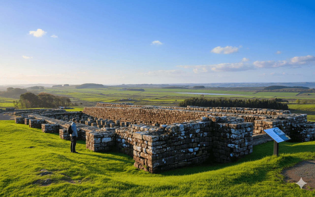
Located near Chollerford, Chesters represents one of the best-preserved Roman cavalry forts in Britain. The site includes remarkable remains of bathhouses, commandant’s house, and the fort layout. English Heritage manages the site (admission charge applies). Budget 45-60 minutes for thorough exploration.
Brocolitia (Carrawburgh) Roman Fort
Approximately 5 miles from Chollerford, this fort site sits just off the path. Though less extensively excavated than Chesters, the adjacent Temple of Mithras offers fascinating insight into Roman religious practices. The temple remains are visible (free access).
Often considered the most impressive fort along Hadrian’s Wall, Housesteads sits approximately 1 mile south of the Wall line. Many walkers make the detour to explore the extensive remains, including latrines, hospital, barracks, and commanding views. English Heritage site (admission charge applies).
The Wall Itself
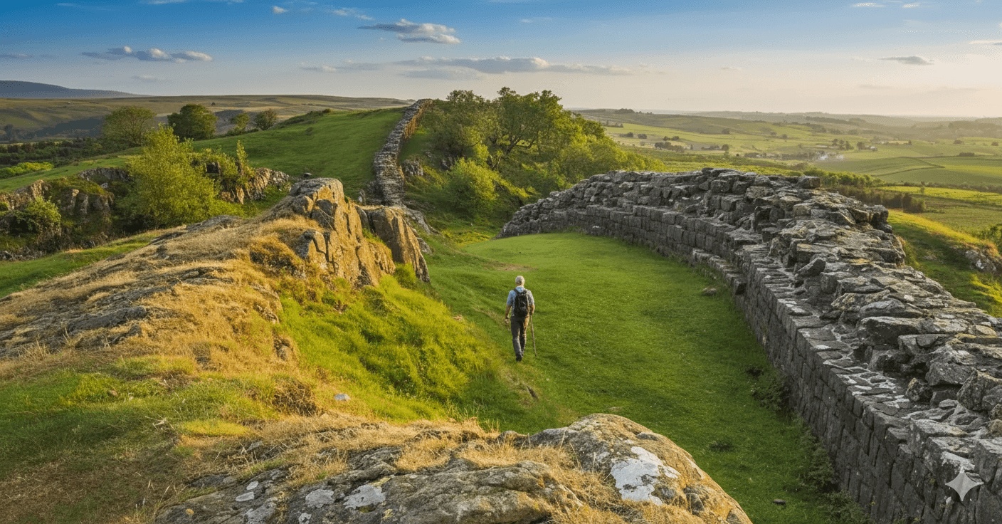
Between Steel Rigg and Housesteads, the Wall runs along the dramatic Whin Sill escarpment, creating the iconic scenery featured in countless photographs. Substantial sections of Wall survive here, offering unparalleled insight into Roman engineering and the monument’s original scale.
Weather Considerations and Exposure
The western portion of this section, particularly the crags between Housesteads and Steel Rigg, ranks among the most exposed terrain on the entire Hadrian’s Wall Path. Weather can change rapidly, and conditions on the crags often differ dramatically from lower elevations.
Weather Challenges
- Wind: The ridge provides no shelter; strong winds are common, occasionally strong enough to make walking difficult
- Rain: Exposed sections offer minimal shelter; waterproofs are essential
- Visibility: Fog can reduce visibility to metres; navigation becomes challenging
- Temperature: Even in summer, temperatures on the crags can be significantly cooler than in valleys
- Winter: Ice and snow make the rocky steps treacherous; some walkers consider microspikes/crampons essential
What to Carry
Regardless of forecast, walkers should carry:
- Waterproof jacket and trousers
- Extra insulating layer (fleece or down jacket)
- Hat and gloves (even in summer months)
- Sufficient food and water
- First aid kit
- Mobile phone (though signal is unreliable)
- Map and compass/GPS device
Difficulty Rating Explained: 7/10
This section receives a 7/10 difficulty rating for several reasons:
Factors Increasing Difficulty:
- Significant cumulative elevation gain/loss
- Exposed, rocky terrain along crags section
- Steep ascents and descents requiring good knee stability
- Length (13 miles is substantial for less experienced walkers)
- Weather exposure and potential for rapid condition changes
- Limited facilities for rest or escape mid-route
Factors Moderating Difficulty:
- Excellent path waymarking
- No technical scrambling required
- Well-maintained National Trail
- Multiple exit points via AD122 bus or taxi
This rating assumes reasonable fitness and some hillwalking experience. Walkers accustomed only to flat terrain will find this section challenging. Those with regular walking experience will find it demanding but achievable with proper preparation.
Who Should Walk This Section?
This section suits walkers who:
- Have good general fitness and stamina for 5-7 hours of walking
- Are comfortable with elevation changes and rocky terrain
- Can manage steep stone steps (both ascending and descending)
- Are prepared for changeable weather conditions
- Have appropriate footwear (walking boots strongly recommended)
Accommodation Considerations
Chollerford Area
Accommodation options near Chollerford include:
- George Hotel, Chollerford (pub with rooms)
- Various B&Bs and guesthouses in surrounding area
- Wall and Humshaugh villages (short distance away)
Once Brewed Area
Once Brewed and nearby villages offer several options:
- Twice Brewed Inn (walkers’ pub with accommodation)
- The Sill hostel accommodation
- Various B&Bs in Once Brewed and Bardon Mill
- Camping options nearby
For self-guided walking holidays, accommodation is typically pre-booked with baggage transferred daily, allowing walkers to complete this challenging section without carrying heavy packs – a significant advantage given the terrain.
Best Time to Walk
Seasonal Considerations
Spring (April-May): Weather improving, fewer crowds, lambing season means some field diversions possible, AD122 bus begins operation
Summer (June-August): Warmest weather, longest daylight, busiest period, best facility opening hours, midges possible in still conditions
Autumn (September-October): Cooler temperatures, beautiful colours, decreasing crowds, AD122 bus operates into September, weather becomes more unpredictable
Most self-guided walking holidays operate April through October, when conditions and facilities are most reliable.
Photography Opportunities
This section offers exceptional photography:
- Chesters Roman Fort bathhouse remains
- Views north from Limestone Corner across rolling countryside
- The Wall snaking along the crags (best from Hotbank Crags looking west)
- Sunset from Winshields Crags
- Sycamore Gap area (note: the famous tree fell in 2023, but the gap remains photogenic)
- Housesteads Fort overlooking the landscape
- Crag Lough reflection shots
Early morning or late afternoon provides the best light along the crags. Midday sun can create harsh shadows and overexposed skies.
Frequently Asked Questions
How long does it take to walk from Chollerford to Once Brewed?
Most walkers complete this section in 5.5 to 7 hours of actual walking time. Allow additional time for stops, photography, lunch breaks, or exploring Roman sites like Chesters or Housesteads. Fitter, faster walkers may complete the route in 5 hours, while those who prefer a leisurely pace, take extensive breaks, or thoroughly explore archaeological sites should allow 7-8 hours plus stops.
Can I walk this section in either direction?
Yes, the route works equally well in both directions. Walking from Chollerford to Once Brewed means the most challenging terrain (the crags) comes later in the day when walkers are potentially more tired, but it also means saving the best scenery for last. Walking from Once Brewed to Chollerford tackles the demanding crag section first whilst fresh, then enjoys easier terrain towards the end. Neither direction is definitively easier – both have merits.
Is the path suitable for families with children?
This section is challenging for families. The 13-mile distance, elevation changes, and exposed rocky terrain along the crags make it unsuitable for younger children or those with limited walking experience. Families with fit teenagers who regularly walk might manage it successfully with proper preparation, adequate breaks, and good weather. The crags section requires particular care with steep drops adjacent to the path in places.
What happens if weather deteriorates whilst on the crags?
Several options exist depending on your location. The AD122 bus stops at Steel Rigg car park (seasonal), approximately 1.5 miles from the highest point at Winshields. Mobile signal is intermittent but sometimes available at higher points for calling a taxi. In genuinely dangerous conditions (white-out, severe storms), the priority is finding what shelter exists behind wall sections and waiting for conditions to improve. Descending south from the Wall reduces exposure slightly.
Are there any steep sections that might be difficult for people with knee problems?
Yes, multiple steep sections exist, particularly along the crags between Steel Rigg and Housesteads where the path ascends and descends repeatedly following the Whin Sill escarpment. These sections include numerous stone steps, both up and down. Walking poles significantly help with knee strain. People with existing knee issues should carefully consider whether this section is appropriate, particularly if carrying any weight. The eastern portion near Chollerford is gentler and more suitable for those with joint problems.
Can I access mobile phone signal along this route?
Mobile signal is unreliable throughout this section. Some signal may be available at road crossings (Chollerford, B6318 Military Road, Once Brewed), but extensive sections, particularly along the crags, have no signal whatsoever. Download offline maps before walking and don’t rely on mobile phones for navigation or emergency communication. Inform someone of your plans and expected arrival time.