Key Points / Quick Summary
- 15.5 miles (25km) of urban and rural walking, starting at the Roman fort of Segedunum
- Difficulty: 4/10 — relatively flat with one moderate climb; suitable for walkers with reasonable fitness
- Excellent facilities throughout, including cafés, pubs, water points, and regular bus links
- Mix of urban Newcastle, riverside paths, and open countryside as the route heads west
- Limited Hadrian’s Wall remains on this section, but rich in industrial and Roman heritage
- Multiple exit points via Metro and bus services make this one of the most flexible sections
Overview of the Wallsend to Heddon-on-the-Wall Section
This opening (or closing) stretch of the Hadrian’s Wall Path National Trail offers a fascinating transition from urban Tyneside into the Northumberland countryside. Starting at Segedunum Roman Fort in Wallsend, the route follows the line of the Wall through Newcastle city centre, along the River Tyne, and eventually climbs into rolling farmland before reaching the historic village of Heddon-on-the-Wall.
Those walking from east to west will experience the gradual shift from city to countryside, whilst walkers heading in the opposite direction enjoy a gentle descent into urban Newcastle. Either way, this section provides an accessible introduction to the Hadrian’s Wall Path, with excellent facilities and transport connections throughout.
The Hadrian’s Wall Path is Britain’s most popular Roman-themed long-distance trail, and booking a self-guided walking holiday allows you to focus on the history and scenery whilst your luggage is transported ahead each day.
Distance and Terrain
The distance between Wallsend and Heddon-on-the-Wall is approximately 15.5 miles (25km). This is one of the longer daily stages on the trail, but the relatively straightforward terrain makes it manageable for walkers with reasonable fitness.
Elevation Profile
The route is predominantly flat through Newcastle, following the riverside and urban streets at near sea level. The significant climb comes after leaving Newburn, where the path ascends approximately 100 metres over 2 miles onto the ridge at Heddon-on-the-Wall. This steady uphill section is the main physical challenge of the day.
Those walking from Heddon-on-the-Wall to Wallsend will benefit from a net descent, though the urban navigation through Newcastle requires concentration.
Cumulative ascent: Approximately 200 metres Highest point: Heddon-on-the-Wall (approximately 110 metres above sea level)
Difficulty Rating: 4/10
This section scores a moderate 4 out of 10 for difficulty. The length requires good stamina, and the climb from Newburn to Heddon provides a workout, but the terrain is never technical. Pavements, cycle paths, and well-maintained tracks make up the majority of the route.
Urban navigation through Newcastle can be slightly challenging, with frequent road crossings and the need to follow waymarking carefully through built-up areas. Allow extra time if you’re walking during rush hour, when busy streets slow progress.
Wayfinding and Navigation
The Hadrian’s Wall Path is generally well-marked with the distinctive acorn National Trail symbol. Through Newcastle, blue wall plaques and pavement markers guide walkers along the Roman Wall line. These can occasionally be obscured or missed amongst shop fronts and street furniture, so keep your eyes open or use a GPS app as backup.
After crossing the River Tyne at Newburn, waymarking is clearer through open countryside. The route follows quiet lanes and field paths with good signage.
Top tip: Download the OS Maps app or carry the Harvey Map for Hadrian’s Wall Path (Central Section). Newcastle city centre can be distracting, and it’s easy to miss a turning.
Starting Point: Segedunum Roman Fort, Wallsend
Segedunum marks the eastern terminus of Hadrian’s Wall. The fort is remarkably well-preserved, with excavated barrack blocks, a reconstructed Roman bathhouse, and an excellent museum. The 35-metre viewing tower offers panoramic views over the site and the Tyne.
Access: Wallsend Metro station (Tyne and Wear Metro yellow line) is a 5-minute walk from Segedunum. Regular services connect to Newcastle Central Station and beyond.
Allow at least 45 minutes to explore the fort before setting off, or visit it the evening before if starting early.
Route Highlights and What to Expect
Through Newcastle (Miles 1–7)
The path follows streets, parks, and riverside walkways through the heart of Newcastle upon Tyne. Key landmarks include:
- St Peter’s Basin and Ouseburn: A revitalised cultural quarter with cafés and independent shops
- Newcastle Quayside: Iconic bridges including the Tyne Bridge and Gateshead Millennium Bridge
- Castle Keep: Newcastle’s Norman castle, built on the site of a Roman fort (not on the trail itself, but worth a short detour)
- Benwell Roman Temple (Vallum): Reconstructed temple remains in a residential area
Whilst visible Roman remains are sparse through the city, interpretation boards and blue plaques trace the Wall’s route. The urban landscape itself tells the story of Newcastle’s industrial heritage, with historic warehouses, shipyards, and Victorian architecture.
Riverside and Newburn (Miles 7–12)
West of Newcastle, the trail joins the Tyne Riverside Country Park and follows the river through Scotswood and Newburn. This section offers welcome greenery after the city streets.
Newburn is a former mining village with a pleasant riverside setting. The Keelman’s Lodge pub overlooks the Tyne and serves food throughout the day.
Climbing to Heddon-on-the-Wall (Miles 12–15.5)
Beyond Newburn, the route leaves the river and climbs steadily through farmland. The ascent is gradual but persistent, gaining 100 metres over approximately 2 miles.
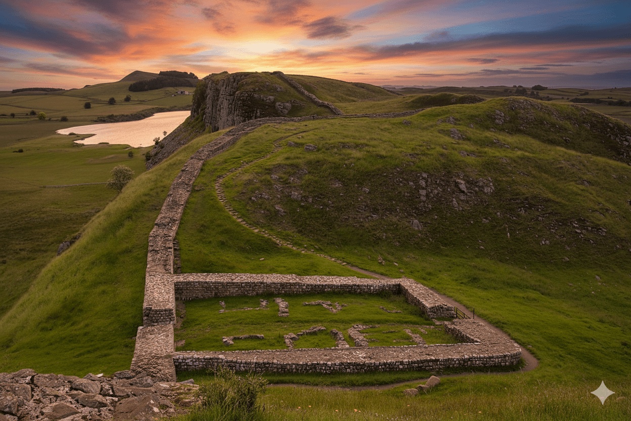
As you approach Heddon-on-the-Wall, the landscape opens up with views across the Tyne Valley. A substantial section of Hadrian’s Wall is visible on the western edge of the village—a welcome sight after the Wall’s absence through Newcastle.
Finishing Point: Heddon-on-the-Wall
Heddon-on-the-Wall is a pleasant village with the Three Tuns Inn and the Swan pub, both serving food and offering accommodation. The village shop stocks basic supplies.
Visible Roman remains: Approximately 100 metres of Hadrian’s Wall survive just past the village, including the Wall ditch.
Water Points and Toilets
This is one of the best-serviced sections of the entire Hadrian’s Wall Path:
- Wallsend/Segedunum: Toilets at the Roman fort museum; cafés and shops nearby
- Newcastle Quayside: Public toilets at various points; numerous cafés and restaurants
- Newburn: Public toilets at Newburn Activity Centre (just off route); water available at cafés and the Keelman’s Lodge pub
- Heddon-on-the-Wall: Village pubs; village hall sometimes open
Carry 1 litre of water, but refilling opportunities are plentiful.
Lunch Options and Pubs
Cafés and Lunch Spots
- Newcastle city centre: Dozens of cafés, takeaways, and supermarkets for packed lunches
- Ouseburn: Trendy cafés and bakeries in the Ouseburn Valley arts quarter
- Newburn: Cafés near Newburn Activity Centre
Pubs
- Keelman’s Lodge, Newburn: Riverside location; food served daily; approximately 11 miles from Wallsend
- Three Tuns, Heddon-on-the-Wall: Traditional village pub; evening meals available
- The Swan, Heddon-on-the-Wall: Food and accommodation
Many walkers aim to reach Newburn for lunch, breaking the day into roughly two halves.
Transport and Exit Points
One of the major advantages of this section is the abundance of public transport.
Metro and Bus Links (Wallsend to Newcastle)
- Wallsend Metro: Yellow line to Newcastle and beyond
- Walker Metro: Approximately 2 miles into the walk
- Byker Metro: Just north of the route, accessible via a short detour
- Newcastle city centre: Multiple Metro stations and bus services; mainline railway station
Bus Services (Newburn to Heddon-on-the-Wall)
- Newburn: Regular buses (Arriva 12/12A) to Newcastle and Hexham
- Heddon-on-the-Wall: Arriva 685 service (hourly) to Newcastle and Carlisle; convenient for onward travel or bail-out options
Taxi services: Available from Newcastle, Newburn, and Heddon. Save local taxi numbers in advance.
The excellent transport links make this section ideal for splitting into two shorter walks if needed.
Weather and What to Wear
Northumberland weather is famously changeable. Even in summer, carry:
- Waterproof jacket and trousers
- Warm mid-layer (fleece or similar)
- Comfortable walking boots with ankle support
- Sun protection: Hat, sunglasses, and suncream in summer
- Layers: Temperature can vary significantly between exposed ridges and sheltered valleys
Urban sections can feel warmer due to buildings retaining heat, but the climb to Heddon-on-the-Wall is exposed to prevailing westerly winds.
Self-Guided Walking Holidays and Baggage Transfer
A self-guided walking holiday along Hadrian’s Wall Path removes the burden of carrying full luggage each day. Baggage transfer services collect your case each morning and deliver it to your next accommodation, allowing you to walk with just a daypack.
Pre-booked accommodation, detailed route notes, and emergency support provide peace of mind, whilst you retain the freedom to walk at your own pace. This Wallsend to Heddon section is typically walked as the first or final stage of a week-long itinerary covering the entire Hadrian’s Wall Path.
Tips for Walking This Section
- Start early if walking in summer to avoid midday heat on exposed sections
- Urban navigation: Pay close attention to waymarking through Newcastle; consider downloading GPX tracks
- Break at Newburn: The riverside setting makes an ideal lunch stop
- Evening arrival: If finishing in Heddon-on-the-Wall, book pub accommodation or an evening meal in advance
- Photography: Wallsend fort museum tower and Newcastle Quayside offer excellent photo opportunities
FAQs
How long does it take to walk from Wallsend to Heddon-on-the-Wall?
Most walkers complete the 15.5 miles in 5.5 to 7 hours, depending on fitness and how many stops are made. Allow extra time for exploring Segedunum fort and navigating through Newcastle. Factor in lunch at Newburn or a café break along the way.
Can I split this section into two shorter walks?
Yes, absolutely. Newburn makes an excellent halfway point with good bus links (Arriva 12/12A) back to Newcastle or onward to Heddon. Alternatively, use the Metro to exit at Walker or Byker in the early miles. The flexibility of public transport on this section is unmatched elsewhere on the trail.
Is the Wallsend to Heddon section suitable for beginners?
The route is accessible for reasonably fit beginners, scoring 4/10 for difficulty. The main challenge is distance rather than technical terrain. Good footpath surfaces and regular facilities make it forgiving for those new to long-distance walking. Split the day at Newburn if concerned about stamina.
Are there any visible remains of Hadrian’s Wall on this section?
Visible Roman remains are limited through Newcastle and Newburn, though interpretation boards mark the Wall’s route. At Heddon-on-the-Wall itself, approximately 100 metres of the Wall survive, including the ditch—a promising sign of what lies ahead (or behind) on the more scenic central sections.
What is the best direction to walk this section?
Walking west (Wallsend to Heddon) allows you to leave the city behind and climb into the countryside, which feels psychologically rewarding. Walking east (Heddon to Wallsend) offers a gentler descent and brings you into Newcastle with energy for evening exploration. Both directions work well; choose based on accommodation availability and personal preference.
Where can I catch a bus or taxi if I need to stop early?
Regular bus services run from Newburn (Arriva 12/12A to Newcastle/Hexham) and Heddon-on-the-Wall (Arriva 685 to Newcastle/Carlisle). Newcastle Metro stations at Wallsend, Walker, and Byker provide easy exits in the first few miles. Local taxi firms serve all settlements along the route—save numbers in your phone before setting out.
Free Ebook: Preparing to Walk Hadrian's Wall
Get your comprehensive guide with essential tips, packing lists, and insider knowledge
Success!
We use cookies to improve your experience and analyse site traffic.